Loading...

Europa Freeways


The Autobahn (German: Autobahn IPA:  plural Autobahnen) is the federal controlled-access highway system in Germany. The official German term is Bundesautobahn (plural Bundesautobahnen, abbreviated BAB), which translates as "federal motorway". The literal meaning of the word Bundesautobahn is "Federal Auto(mobile) Track".

German autobahns have no federally mandated speed limit for some classes of vehicles.However, limits are posted (and enforced) in areas that are urbanized, substandard, accident-prone, or under construction. On speed-unrestricted stretches, an advisory speed limit (Richtgeschwindigkeit) of 130 kilometres per hour (81 mph) applies. While going faster is not illegal as such in the absence of a speed limit, it can cause an increased liability in the case of an accident; courts have ruled that an "ideal driver" who is exempt from absolute liability for "inevitable" tort under the law would not exceed Richtgeschwindigkeit.


A 2008 estimate reported that 52% of the autobahn network had only the advisory speed limit, 15% had temporary speed limits due to weather or traffic conditions, and 33% had permanent speed limits. Measurements from the German State of

Brandenburg in 2006 showed average speeds of 142 km/h (88 mph) on a 6-lane section of autobahn in free-flowing conditions.

Germany's autobahn network has a total length of about 12,996 kilometres (8,075 mi) in 2017, which ranks it among the most dense and longest controlled-access systems in the world. Longer similar systems can be found in the
United States (77,017 kilometres (47,856 mi))and in China (123,000 kilometres (76,000 mi))
However both the U.S. and China have an area nearly 30 times bigger than Germany, which demonstrates the high density of Germany's highway system


Emergency telephones

Emergency telephone
Directional arrow on a delineator

About 16,000 emergency telephones are distributed at regular intervals all along the autobahn network, with triangular stickers on the armco barriers pointing the way to the nearest one. Despite the increasing use of mobile phones, there are still some 700 calls made each day on average.

For the Emergency service or Roadside assistance to come to the right location, the road kilometre must be given as part of the emergency call

Parking, rest areas and truck stops

 
Road kilometre sign German federal motorway "Autobahn 6", km 565.0 near Mannheim

For breaks during longer journeys, parking sites, rest areas and truck stops are distributed over the complete Autobahn network. Parking on the autobahn is prohibited in the strictest terms outside these designated areas. There is a distinction between "managed" and "unmanaged" rest areas. (German: bewirtschaftet / unbewirtschaftet).

Parking sign

Unmanaged rest areas are basically only parking spaces, sometimes with toilets. They form a part of the German highway system; the plots of land are federal property. Autobahn exits leading to such parking areas are marked 200 metres in advance with a blue sign with the white letter "P". They are found every few kilometres.

A managed rest area (German: Autobahnraststätte or Raststätte for short) usually also includes a filling station, charging station, lavatories, toilets and baby changes. Many rest areas also have restaurants, shops, public telephones, internet access and a playground. Some have hotels. Mandated every 50 km or so, rest areas are usually open all night.

Both kinds of rest areas are directly on the autobahn, with their own exits, and any service roads connecting them to the rest of the road network are usually closed to general traffic. The autobahn must not be left at rest areas.

Zeichen 448.1 - Autohof, StVO 2000.svg

Truck stops (German Autohof, plural Autohöfe) are far rarer. Located at general exits, usually at a small distance from the autobahn, they have no ramps of their own.

Truck stop Scandinavian Park off the A 7
Rest area Dammer Berge on the A 1
Rest areas and truck stops are marked several times, starting several kilometres in advance, and with larger signs that often include icons announcing what kinds of facilities travellers can

Except at construction sites, the general speed limits, where they apply, are usually between 100 km/h (62 mph) and 130 km/h (81 mph); construction sites usually have a speed limit of 80 km/h (50 mph) but the limit may be as low as 60 km/h (37 mph).In rare cases, sections may have limits of 40 km/h (25 mph), or on one ramp 30 km/h (19 mph) Certain stretches have lower speed limits during wet weather. Some areas have a speed limit of 120 km/h (75 mph) in order to reduce noise pollution during overnight hours (usually 10pm – 6am) or because of increased traffic during daytime (6am – 8pm).

 
Dynamic traffic signs on an Autobahn

Some limits were imposed to reduce pollution and noise. Limits can also be temporarily put into place through dynamic traffic guidance systems that display the according message. More than half of the total length of the German autobahn network has no speed limit, about one third has a permanent limit, and the remaining parts have a temporary or conditional limit.

Some cars with very powerful engines can reach speeds of well over 300 km/h (190 mph). Major German car manufacturers, except Porsche, follow a gentlemen's agreement by electronically limiting the top speeds of their cars—with the exception of some top of the range models or engines—to 250 km/h (155 mph). These limiters can be deactivated, so speeds up to 300 km/h (190 mph) might arise on the German autobahn, but due to other traffic, such speeds are generally not attainable except during certain times like between 10 p.m. and 6 a.m. or on Sundays (when trucks drivers have to rest by law). Furthermore, there are certain autobahn sections which are known for having light traffic, making such speeds attainable during most days (especially some of those located in Eastern Germany). Most unlimited sections of the autobahn are located outside densely populated areas.

Vehicles with a top speed less than 60 km/h (37 mph) (such as quads, low-end microcars, and agricultural/construction equipment) are not allowed to use the autobahn, nor are motorcycles and scooters with low engine capacity regardless of top speed (mainly applicable to mopeds which are typically limited to 25 or 45 km/h anyway). To comply with this limit, heavy-duty trucks in Germany (e.g. mobile cranes, tank transporters etc.) often have a maximum design speed of 62 km/h (39 mph) (usually denoted by a round black-on-white sign with "62" on it), along with flashing orange beacons to warn approaching cars that they are travelling slowly. There is no general minimum speed but drivers are not allowed to drive at an unnecessarily low speed as this would lead to significant traffic disturbance and an increased collision risk.


The idea for the construction of the autobahn was first conceived in the mid-1920s during the days of the Weimar Republic, but the construction was slow, and most projected sections did not progress much beyond the planning stage due to economic problems and a lack of political support. One project was the private initiative HaFraBa which planned a "car-only road" crossing Germany from Hamburg in the north via central Frankfurt am Main to Basel in Switzerland. Parts of the HaFraBa were completed in the late 1930s and early 1940s, but construction eventually was halted by World War II. The first public road of this kind was completed in 1932 between Cologne and Bonn and opened by Konrad Adenauer (Lord Mayor of Cologne and future Chancellor of West Germany) on 6 August 1932.Today, that road is the Bundesautobahn 555.This road was not yet called Autobahn and lacked a center median like modern motorways, but instead was termed a Kraftfahrstraße ("motor vehicle road") with two lanes each direction without intersections, pedestrians, bicycles, or animal-powered transportation.

 
One of the center pier-free bridges over the former Dessauer Rennstrecke on Autobahn A9


Just days after the 1933
Nazi takeover, Adolf Hitler enthusiastically embraced an ambitious autobahn construction project, appointing Fritz Todt, the Inspector General of German Road Construction, to lead it. By 1936, 130,000 workers were directly employed in construction, as well as an additional 270,000 in the supply chain for construction equipment, steel, concrete, signage, maintenance equipment, etc. In rural areas, new camps to house the workers were built near construction sites. The job creation program aspect was not especially important because full employment was almost reached by 1936. The autobahns were not primarily intended as major infrastructure improvement of special value to the military as often stated. Their military value was limited as all major military transports in Germany were done by train to save fuel. The propaganda ministry turned the construction of the autobahns into a major media event that attracted international attention.


The autobahns formed the first limited-access, high-speed road network in the world, with the first section from Frankfurt am Main to Darmstadt opening in 1935. This straight section was used for high-speed record attempts by the Grand Prix racing teams of Mercedes-Benz and Auto Union until a fatal accident involving popular German race driver Bernd Rosemeyer in early 1938. The world record of 432 kilometres per hour (268 mph) set by Rudolf Caracciola on this stretch just prior to the accident remains one of the highest speeds ever achieved on a public motorway. A similar intent in the 1930s existed for a ten-kilometre stretch of what is today Bundesautobahn 9 just south of Dessau—called the Dessauer Rennstrecke—had bridges with no piers, meant for land speed record cars like the Mercedes-Benz T80 to have made a record attempt in January 1940, abandoned due to the outbreak of World War II in Europe four months earlier.

Overall length
Year km
Year km
1935 108
1975 5,742
1936 1,086
1980 7,292
1937 2,010
1985 8,198
1938 3,046
1990 8,822
1939 3,300
1995 11,143
1940 3,736
2000 11,515
1950 2,128
2005 12,174
1955 2,187
2010 12,813
1960 2,551
2015 12,949
1965 3,204
2016 12,993
1970 4,110


During World War II, the
median strips of some autobahns were paved over to allow their conversion into auxiliary airstrips. Aircraft were either stashed in numerous tunnels or camouflaged in nearby woods. However, for the most part during the war, the autobahns were not militarily significant. Motor vehicles, such as trucks, could not carry goods or troops as quickly or in as much bulk and in the same numbers as trains could, and the autobahns could not be used by tanks as their weight and caterpillar tracks damaged the road surface. The general shortage of petrol in Germany during much of the war, as well as the low number of trucks and motor vehicles needed for direct support of military operations, further decreased the autobahn's significance. As a result, most military and economic freight was carried by rail. After the war, numerous sections of the autobahns were in bad shape, severely damaged by heavy Alliedbombing and military demolition. Furthermore, thousands of kilometres of autobahns remained unfinished, their construction brought to a halt by 1943 due to the increasing demands of the war effort.

 
The A 3 in 1991

In West Germany (FRG), most existing autobahns were repaired soon after the war. During the 1950s, the West German government restarted the construction program. It invested in new sections and in improvements to older ones. Finishing the incomplete sections took longer, with some stretches opened to traffic by the 1980s. Some sections cut by the Iron Curtain in 1945 were only completed after German reunification in 1990. Others were never completed, as more advantageous routes were found. Some of these incomplete sections to this very day stretch across the landscape forming a unique type of modern ruin, often easily visible on satellite photographs.


The autobahns of East Germany (GDR) were neglected in comparison to those in West Germany after 1945. East German autobahns were used primarily for GDR military traffic and for state-owned farming or manufacturing vehicles. The speed limit on the GDR autobahns was 100 km/h; however, lower speed limits were frequently encountered due to poor or quickly changing road conditions. The speed limits on the GDR autobahns were rigorously enforced by the

Volkspolizei, whose patrol cars were frequently found hiding under camouflage tarpaulins waiting for speeders.


The last four kilometres of remaining original Reichsautobahn, a section of
A 11 northeast of Berlin near Gartz built in 1936—the westernmost remainder of the never-finished Berlinka—are scheduled for replacement around 2015. Roadway condition is described as "deplorable"; the 25-metre-long concrete slabs, too long for proper expansion, are cracking under the weight of the traffic as well as the weather.


Public debate

German national speed limits have a historical association with war-time restrictions and deprivations, the Nazi era, and the Soviet era in East Germany. "Free driving for free citizens" ("freie Fahrt für freie Bürger"), a slogan promoted by the German Auto Club since the 1970s, is a popular slogan among those opposing autobahn speed restrictions. Tarek Al-Wazir, head of the Green Party in Hesse, and currently the Hessian Transport Minister has stated that "the speed limit in Germany has a similar status as the right to bear arms in the American debate... At some point, a speed limit will become reality here, and soon we will not be able to remember the tim
e before. It's like the smoking ban in restaurants."


Early history

The
Weimar Republic had no federally required speed limits. The first crossroads-free road for motorized vehicles only, now A555 between Bonn and Cologne, had a 120 km/h (75 mph) limit when it opened in 1932. In October 1939, the Nazis instituted the first national maximum speed limit, throttling speeds to 80 km/h (50 mph) in order to conserve gasoline for the war effort. After the war, the four Allied occupation zones established their own speed limits until the divided East German and West German republics were constituted in 1949; initially, the Nazi speed limits were restored in both East and West Germany


Toll roads

On 1 January 2005, a new system came into effect for mandatory tolls (Mautpflicht) on heavy trucks (those weighing more than 12 t) while using the German autobahn system (LKW-Maut). The German government contracted with a private company, Toll Collect GmbH, to operate the toll collection system, which has involved the use of vehicle-mounted transponders and roadway-mounted sensors installed throughout Germany. The toll is calculated depending on the toll route, as well as based on the pollution class of the vehicle, its weight and the number of axles on the vehicles. Certain vehicles, such as emergency vehicles and buses, are exempt from the toll. An average user is charged €0.15 per kilometre, or about $0.31 per mile (Toll Collect, 2007).

 Only federally built controlled-access highways with certain construction standards including at least two lanes per direction are called Bundesautobahn. They have their own, white-on-blue signs and numbering system. In the 1930s, when construction began on the system, the official name was Reichsautobahn. Various other controlled-access highways exist on the federal (Bundesstraße), state (Landesstraße), district, and municipal level but are not part of the Autobahn network and are officially referred to as Kraftfahrstraße (with rare exceptions, like A 995 Munich-Giesing–Brunntal). These highways are considered autobahnähnlich (autobahn-like) and are sometimes colloquially called Gelbe Autobahn (yellow autobahn) because most of them are Bundesstraßen (federal highways) with yellow signs. Some controlled-access highways are classified as "Bundesautobahn" in spite of not meeting the autobahn construction standard (for example the A 62 near Pirmasens).

Similar to high-speed motorways in other countries, autobahns have multiple lanes of traffic in each direction, separated by a central barrier with grade-separated junctions and access restricted to motor vehicles with a top speed of more than 60 km/h (37 mph). Nearly all exits are to the right. The earliest motorways were flanked by shoulders about 60 centimetres (24 in) in width, constructed of varying materials; right-hand shoulders on many autobahns were later retrofitted to 120 centimetres (47 in) in width when it was realized cars needed the additional space to pull off the autobahn safely. In the postwar years, a thicker asphaltic concrete cross-section with full paved hard shoulders came into general use. The top design speed was approximately 160 km/h (99 mph) in flat country but lower design speeds were used in hilly or mountainous terrain. A flat-country autobahn that was constructed to meet standards during the Nazi period, could support the speed of up to 150 km/h (93 mph) on curves.

The current autobahn numbering system in use in Germany was introduced in 1974. All autobahns are named by using the capital letter A, which simply stands for "Autobahn" followed by a blank and a number (for example A 8). The main autobahns going all across Germany have a single digit number. Shorter autobahns that are of regional importance (e.g. connecting two major cities or regions within Germany) have a double digit number (e.g. A 24, connecting Berlin and Hamburg). The system is as follows:

There are also some very short autobahns built just for local traffic (e.g. ring roads or the A 555 from Cologne to Bonn) that usually have three digits for numbering. The first digit used is similar to the system above, depending on the region. East-west routes are always even-numbered, north-south routes are always odd-numbered.


The north-south autobahns are generally numbered using odd numbers from west to east; that is to say, the more easterly roads are given higher numbers. Similarly, the east-west routes are numbered using even numbers from north (lower numbers) to south (higher numbers).

Speed limits

 
Autobahn with three separate lanes in each direction and an emergency lane
 
On the autobahns there is an advisory speed limit (Richtgeschwindigkeit) of 130 km/h (unless otherwise regulated by signs).
 
The "limits no longer apply" (Ende aller Streckenverbote) sign, indicating a return to the default speed, while lifting all other limits as well (all limits are indicated by round signs with red border).
 
GPS tracks colored according to speed show considerable speed differences at an autobahn crossing

Germany's autobahns are famous for being among the few public roads in the world without blanket speed limits for cars and motorcycles. As such, they are important German cultural identifiers, "... often mentioned in hushed, reverential tones by motoring enthusiasts and looked at with a mix of awe and terror by outsiders." Some speed limits are implemented on different autobahns.

Certain limits are imposed on some classes of vehicles:

60 km/h (37 mph)
  • Buses carrying standing passengers
  • Motorcycles pulling trailers
80 km/h (50 mph)
  • Vehicles with maximum allowed weight exceeding 3.5 t (except passenger cars)
  • Passenger cars and trucks with trailers
  • Buses
100 km/h (62 mph)
  • Passenger cars pulling trailers certified for 100 km/h
  • Buses certified for 100 km/h not towing trailers

Additionally, speed limits are posted at most on- and off-ramps and interchanges and other danger points like sections under construction or in need of repair.

Where no general limit is required, the advisory speed limit is 130 km/h (81 mph), referred to in German as the Richtgeschwindigkeit. The advisory speed is not enforceable; however, being involved in an accident driving at higher speeds can lead to the driver being deemed at least partially responsible due to "increased operating danger" (Erhöhte Betriebsgefahr).

The Federal Road Research Institute (Bundesanstalt für Straßenwesen) solicited information about speed regulations on autobahns from the sixteen States and reported the following, comparing the years 2006 and 2008:


German-built Reichsautobahnen in other countries

The first autobahn in Austria was the West Autobahn from Wals near Salzburg to Vienna. Building started by command of Adolf Hitler shortly after the Anschluss in 1938. It extended the Reichsautobahn 26 from Munich (the present-day A8), however only 16.8 km (10.4 mi) including the branch-off of the planned Tauern Autobahn was opened to the public on 13 September 1941. Construction works discontinued the next year and were not resumed until 1955.

There are sections of the former German Reichsautobahn system in the former eastern territories of Germany, i.e. East Prussia, Farther Pomerania and Silesia; these territories became parts of Poland and the Soviet Union with the implementation of the Oder–Neisse line after World War II. Parts of the planned autobahn from Berlin to Königsberg (the Berlinka) were completed as far as Stettin (Szczecin) on 27 September 1936. After the war, they were incorporated as the A6 autostrada of the Polish motorway network. A single-carriageway section of the Berlinka east of the former "Polish Corridor" and the Free City of Danzig opened in 1938; today it forms the Polish S22 expressway from Elbląg (Elbing) to the border with the Russian Kaliningrad Oblast, where it is continued by the R516 regional road. Also on 27 September 1936, a section from Breslau (Wrocław) to Liegnitz (Legnica) in Silesia was inaugurated, which today is part of the Polish A4 autostrada, followed by the (single vehicle) Reichsautobahn 9 from Bunzlau (Bolesławiec) to Sagan (Żagań) the next year, today part of the Polish A18 autostrada.

After the German occupation of Czechoslovakia, plans for a motorway connecting Breslau with Vienna via Brno (Brünn) in the "Protectorate of Bohemia and Moravia" were carried out from 1939 until construction works discontinued in 1942. A section of the former Strecke 88 near Brno is today part of the R52 expressway of the Czech Republic.


Safety

In 2014, autobahns carried 31% of motorized road traffic while accounting for 11% of Germany's traffic deaths. The autobahn fatality rate of 1.6 deaths per billion travel-kilometres compared favorably with the 4.6 rate on urban streets and 6.5 rate on rural roads.

Between 1970 and 2010, overall German road fatalities decreased by almost 80% from 19,193 to 3,648; over the same time period, autobahn deaths halved from 945 to 430 deaths. Statistics for 2013 show total German traffic deaths had declined to the lowest count ever recorded: 3,340 (428 on autobahns); a representative of the Federal Statistical Office attributed the general decline to harsh winter weather that delayed the start of the motorcycle-riding season. In 2014, there was a total of 3,377 road fatalities, while autobahn deaths dropped to 375.

Road Class Injury Crashes Fatalities Injury Rate* Fatality Rate* Fatalities per 1000 Injury Crashes
Autobahn 18,901 375 0.082 1.6 19.8
Urban 209,618 983 1.052 4.9 4.7
Rural 73,916 2,019 0.238 6.5 27.3
Total 302,435 3,377 0.408 4.6 11.2

* per 1,000,000,000 travel-kilometres

In 2012, the leading cause of autobahn accidents was "excessive speed (for conditions)": 6,587 so-called "speed related" crashes claimed the lives of 179 people, which represents almost half (46.3%) of 387 autobahn fatalities that year. However, "excessive speed" does not mean that a speed limit has been exceeded, but that police determined at least one party travelled too fast for existing road or weather conditions. On autobahns 22 people died per 1,000 injury crashes; a lower rate than the 29 deaths per 1,000 injury accidents on conventional rural roads, which in turn is five times higher than the risk on urban roads—speeds are higher on rural roads and autobahns than urban roads, increasing the severity potential of a crash


Highway tableGermany flagSpeed limits in Germany


Germany speed limits


Highway tolls in Germany

Navigating Europe by Car: Apps, Maps, and Trip Tips

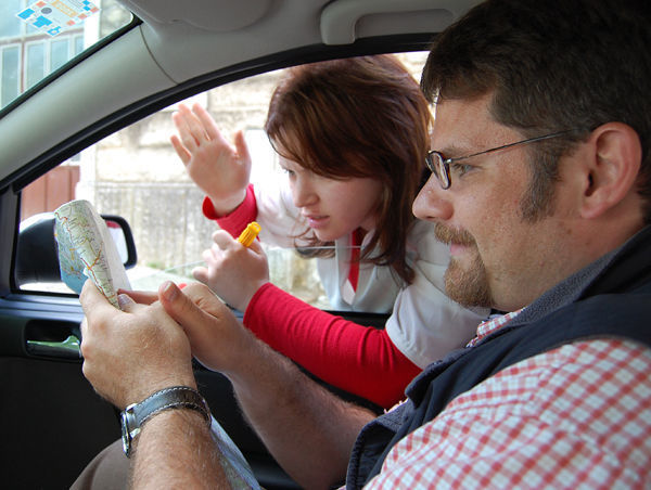
No map is ever quite as good as advice from a helpful local.
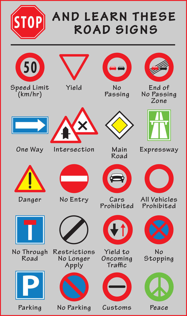
All of Europe uses the same simple set of road symbols.

Phone-based map apps have taken much of the pain out of finding our way on road trips. But what about when we're overseas, where a phone connection might not be all that cheap, or fast? No road trip is without its wrong turns — but deciding on the best map apps, whether to use a GPS device, and arming yourself with some key tips for navigating in Europe can go a long way toward saving time and frustration.

My best tip for navigating unfamiliar terrain: Don't rely blindly on your phone's mapping app or a GPS device for directions. Always have at least a vague sense of your route, keep a paper map handy, and pay attention to road signs so you can consider alternatives if you feel the GPS route is Getting Pretty Screwy.

Maps and Apps

Whether it's a map app on your phone or an old-school driver's atlas, a well-designed map of any kind is a must-have on any European road trip.

Mobile Mapping Apps

The mapping app on your phone works fine for navigating Europe's roads. The downside is that to get real-time turn-by-turn directions and traffic updates, you'll need Internet access (a concern abroad, where you are likely paying more for data).

For most travelers concerned about data roaming, the best option is an app that works offline: Google Maps, Here WeGo, and Navmii will give you turn-by-turn voice directions without a data connection — and if you make a wrong turn, will recalibrate and send you on the right way. They essentially offer nearly all the advantages of a dedicated GPS system, but on your smartphone — for free.

Download your map before you head out (it's smart to select a large region). Then turn off your cellular connection so you're not charged for data roaming. Call up the map, enter your destination, and you're on your way. For the best performance in Google Maps, use standard view (not satellite view) to limit data demands.

Be aware that Google Maps' traffic setting does not work offline, so check for slowdowns and detours before you hit the road or use data roaming for a brief period to get current conditions. And bring a car charger for your device, since mapping apps, even offline, gobble up battery life. It's also smart to bring a car mount for your phone that works for lots of vehicles.

As of the last update to this article, other navigation apps — such as Apple Maps and Waze — do not offer turn-by-turn directions offline. GPS apps from TomTom, Garmin, CoPilot, and others do work offline but tend to be very expensive.

GPS Devices

If you'll be traveling without a smartphone, or want the convenience of a dedicated GPS, consider renting a GPS device with your car ($10–30 per day). It'll give you real-time turn-by-turn directions and traffic without the data limitations of a phone app. Note that the unit may come loaded only with maps for its home country; if you need additional maps, ask. Also make sure the device is set to English before you drive off.

The other option is to bring a GPS from home. You'll likely need to buy and download European maps before your trip (check that the maps available through the manufacturer are detailed enough for the areas you're visiting). Remember to bring your unit's car charger and a portable car mount.

Paper Maps and Atlases

Even when navigating primarily with a phone app or a GPS device, I always have a paper map on hand. It's invaluable for getting the big picture, understanding alternate routes, and filling in when my phone runs out of juice.

The free maps you get from your car-rental company usually don't have enough detail. Better maps and atlases are sold at European gas stations, bookshops, newsstands, and tourist shops. Michelin offers good individual regional maps and road atlases for each country (with good city maps and detailed indexes). Though they can be heavy, atlases are compact, a good value, and easier for drivers to use than big foldout maps.

Sometimes the best regional road maps are available locally. For example, if you're exploring your roots in the Norwegian fjord country, Cappelens 1:200,000 maps are detailed enough to help you find Grandpa Ole's farm. Other quality European brands include Hallwag, Freytag & Berndt, Marco Polo, Berndtson & Berndtson, AA (Britain's AAA-type automobile club), Road Editions (for Greece), and Kod & Kam (for Croatia and Slovenia).

Smart Navigation

Your trip will go more smoothly if you familiarize yourself with the quirks of navigating in Europe.

Signs and Symbols

All of Europe uses the same simple set of road symbols; it takes just a few minutes to learn them (see image). Many superhighway rest stops have local driving almanacs (or cheap maps) that explain such signs, roadside facilities, and exits.

Metric Distances

European countries (except the UK) use kilometers instead of miles. One kilometer is six-tenths of a mile. To convert kilometers to miles, cut the kilometers in half and add 10 percent of the original number (360 km = 180 + 36 = 216 miles; 90 km/hour = 45 + 9 = 54 mph — not very fast in Europe). Some people prefer to drop the last digit and multiply by 6 (if 80 km, multiply 8 × 6 = 48 miles), though this can be challenging with large numbers (340 km × 6 = ?). Choose whichever formula works for you.

When estimating how long a drive will take, figure you'll average 100 kilometers per hour on expressways (about the same as going 60 mph back home). Determining how much ground you can cover off the freeway is a crapshoot. I use a trick an Irish bus driver taught me: Figure a minute for every kilometer (covering 90 km will take you about an hour and a half). Double that for slow, curvy roads, such as in Italy's Dolomites or along its Amalfi Coast.

Navigating by Road and Town Names

Study the roads and major interchanges you'll be using before you set out. If you're headed for a small or midsize town, know which big city is nearby (and most likely to be signposted) to keep you headed in the right direction.

In some countries, road numbers can help you find your way: For example, take road A-1 to London, then B-23 to Bristol, then C-456 to Bath. Normally, the more digits the road number has, the smaller it is; so in Britain, M-1 is a freeway, A-34 is a major road, and B-4081 is a secondary road. In other countries, local signs ignore the road numbers (which can change along the way), so it's necessary to navigate by town name. Signs are often color-coded: yellow for most roads, green or blue for expressways, and brown for sightseeing attractions.

Most international European expressways are designated with an "E" (similar to the "I" designation on American freeways), but they may also be labeled on maps and signs with their national letters (for example, the main route between Paris and Lyon is known as both "A-6" and "E-15").

City Centers

You can drive in and out of strange towns fairly smoothly by following a few basic signs. Most European towns have signs directing you to the "old town" or the center (such as centrum, centro, centar, centre-ville, Zentrum, Stadtmitte). Most tourist offices, normally right downtown, are clearly signposted (i, turismo, VVV, or various abbreviations that you'll learn in each country). The tallest spire often marks the center of the old town. Park in its shadow and look for the tourist information office. When leaving a city, look for "all directions" signs (toutes directions, alle Richtungen, etc.) pointing you out of town.

When you reserve your hotel room, ask your hotelier — or at least check their website — for tips on avoiding anything potentially tricky about reaching the hotel by car (especially if your hotel's in a dense Old World maze of streets). If possible, figure out your arrival route before you enter the city limits. While some small towns helpfully post signs directing you to individual hotels, in many cases you're on your own. If your hotel is within a restricted driving area, ask your hotelier to register your car ahead of your arrival or direct you to legal parking.

Tolls.eu is a website whose goal is to build a complete overview of prices paid road sections in Europe. Here you will find listings of prices vignettes and charges for individual states, including maps highlighting the toll. When traveling in unfamiliar international locations you can use to plan your journey overview of fuel prices in Europe.

Germany motorway maps

- Puttgarden - Oldenburg in Holstein - Bad Schwartau - Lübeck - Bargteheide - Hamburg - Maschen - Horst - Buchholz - Bremen - Stuhr - Cloppenburg - Osnabrück - Münster - Hamm - Kamen - Dortmund/Unna - Schwerte- Hagen - Wuppertal - Leverkusen - Köln - Erftstadt - Bliesheim - Euskirchen - Blankenheim - - Daun - Wittlich - Schweich - Trier - Nonnweiler - Saarbrücken
Oberhausen - Bottrop - Gladbeck - Gelsenkirchen - Recklinghausen - Dortmund- Kamen - Hamm - Bielefeld - Herford - Bad Oyenhausen - Hannover - Braunschweig - Wolfsburg - Magdeburg - Brandenburg - Berliner Ring
- Elten - Wesel - Oberhausen - Duisburg - Breitscheid - Ratingen - Düsseldorf - Hilden - Langenfeld - Leverkusen - Köln - Siegburg - Dernbach - Limburg - Wiesbaden - Mönchhof - Frankfurt am Main - Offenbach - Seiligenstadt- Aschaffenburg - Würzburg - Erlangen - Nürnberg - Altdorf - Regensburg - Deggenburg - Passau - Pocking -
- Aachen - Kerpen - Köln - Gummersbach - Olpe- Krombach - - Bad Hersfeld - Wommen - Eisenach - Erfurt - Weimar - Jena - Hermsdorf - Gera - Meerane - Chemnitz - Nossen - Dresden - Bautzen - Görlitz -
Hattenbach - Homberg - Reiskirchen - Gambach- Bad Homburg - Frankfurt am Main - Darmstadt - Weinheim - Heidelberg - Walldorf - Karlsruhe - Baden-Baden - Offenburg - Freiburg/Breisgau - Neuenburg - Weil am Rhein -
- Saarbrücken - Neunkirchen - Landstuhl - Kaiserslautern - Frankenthal - Viernheim - Mannheim - Hockenhaim - Walldorf - Heilbronn - Crailsheim/Feuchtwangen - Ansbach - Nürnberg - Altdorf - Amberg - Wernberg - Waidhaus -
- Flensburg - Schleswig - Rendsburg - Neumünster - Hamburg - Maschen - Horst - Walsrode - Hannover - Hildesheim - Salzgitter - Göttingen - Kassel- Bad Hersfeld - Hattenbach - Fulda - Werneck - Würzburg - Crailsheim/Feuchtwangen - Aalen - Heideheim - Ulm/Elchingen - Neu Ulm - Memmingen - Kempten - AD Allgäu - Füssen -
- Perl - Saarlouis - Saarbrücken - Neunkirchen - Friedrichsthal - Pirmasens - Karlsruhe - Pforzheim - Leonberg - Stuttgart - Ulm/Elchingen - Augsburg - München - München - Rosenheim - Bad Reichenhall -
Berlin - Dessau - Leipzig - Rippach - Hermsdorf - Hof - Bayreuth - Nürnberg - Feucht - Ingolstadt - Pfaffenhofen - Neufahrn - München
AD Schwanebeck - AD Spreeau - AK Schönefeld - Ludwigsfelde - AD Nuthetal - AD Potsdam - AD Werder - Spandau - AD Havelland - AK Oranienburg - AD Pankow - AD Schwanebeck
- Pomellen - Prenzlau - Eberswalde-Finow - Bernau - Berlin
Berlin - Fürstenwalde - Frankfurt an der Oder -
Berlin - Lübbenau - Großräschen - Dresden
Wismar - Schwerin - - Magdeburg - Bernburg - Halle - Leipzig - Döbeln - Nossen
Lübbenau - Cottbus - Bademeusel -
Dresden - Pirna - Bad Gottleuba -
Rostock - Güstrow - Wittstock
-Lübeck - Wismar - Rostock - Greifswald - Neubrandenburg - Prenzlau
- Wankendorf - Bad Segeberg - Bad Oldesloe - Bargteheide
Heide - Itzehoe - Steinburg - Elmshorn - Hamburg
Hamburg - Schwarzenbek - Schwerin - Wittstock - Neuruppin - Berlin
Hamburg - Geesthach
Stade - Horneburg - Buxtehude -
Cuxhaven - Bremerhaven - Bremen - Walsrode
Leer - Westerstede - Oldenburg - Delmenhorst - Stuhr
Wilhelmshaven - Varel - Jaderberg - Oldenburg - Cloppenburg
- Bad Bentheim - Schüttorf - Rheine - Ibbenbühren - Lotte - Osnabrück - Löhne -- Bad Oeynhausen
Emden - Leer - Bunde - Meppen - Lingen - Schüttorf - Gronau/Ochtrup - Gladbeck - Bottrop
- Osnabrück - Borgholzhausen -- Bielefeld - Paderborn - AK Wünnenberg-Haaren
Burgdorf - Hannover-Buchholz - Hannover-Misburg - Hannover-Messe - AD Hannover-Süd
Göttingen - Heiligenstadt - Nordhausen - Sangerhausen - Halle - Merseburg - Rippach - Leipzig
- Wolfsburg - AK Wolfsburg-Königslutter - Braunschweig - Salzgitter
- Straelen - Kempen - Moers - Duisburg - Mülheim an der Ruhr - Essen - Gelsenkirchen - Bochum - Dortmund
Kamp-Lintfort - Duisburg - Oberhausen - Bottrop - Essen - Gelsenkirchen - Herne - Castrop-Rauxel - Dortmund
Münster - Marl - Recklinghausen - Herne - Bochum - Wuppertal


Travel Tips: Transportation

Figuring out how to get around in Europe is one of your biggest pre-trip decisions. Get Rick’s best advice on deciding between your options and navigating Europe’s roads, railways, and urban transit.


- Aachen - Jackerath - Mönchengladbach -- Krefeld - Düsseldorf - Ratingen -- Velbert - - Bochum - Witten --Dortmund - Unna - Werl - Soest - Büren - AK Wünnenberg-Haaren - Warburg - Kassel-- Hessisch Lichtenau -
Dortmund - Witten - Schwerte - Hagen - Lüdenscheid - Olpe - Siegen - Wetzlar - Gießen - Gambach - Langenselbold - Hanau - Seiligenstadt/Aschaffenburg
- Heinsberg - Mönchengladbach - Jüchen/Grevenbroich - Neuss - Düsseldorf - Hilden - Sonnborn- Wuppertal --Hagen - Iserlohn - Hemer - - Menden - Arnserg - Meschede - Bestwig -
Daun - Mayen - Koblenz - Montabaur
Kassel - Fritzlar - Neuental -
- Elmpt - Mönchengladbach - Kaarst - Düsseldorf -- Breitscheid - Essen -- Gladbeck - Gelsenkirchen - Marl
- Goch - Kamp-Lintfort - Moers - Krefeld - Kaarst - Neuss - Köln
Dinslaken - Duisburg --Düsseldorf - Monheim - Leverkusen --lKöln - Flughafen Köln-Bonn - Troisdorf - St. Augustin - Bonn
- Winterspelt - Bitburg - Wittlich -- Bingen - Mainz - Gustavsburg - Rüsselsheim
- Kaldenkirchen - Nettetal - Viersen - Mönchengladbach - Jackerath - Bergheim - Kerpen - Erftstadt - Bliesheim - Swisttal - Meckenhaim - Bad Neuenahr-Ahrweiler - Sinzig - Koblenz - Bingen - Bad Kreuznach - Alzey - Worms - Frankenthal - Ludwigshafen - Mutterstadt - Speyer - Hockenheim
Nonnweiler - Birkenfeld - Kusel - Landstuhl - Pirmasens
Mainz - Alzey - Kaiserslautern
- Mesenich - Trier -
Ludwigshafen - Mutterstadt - Neustadt - Landau - Kandel - Wörth am Rhein --Lauterbourg -
Wiesbaden - Wiesbadener Kreuz - Kriftel - Eschborn - Frankfurt am Main -- Hanau - Schlüchtern -- Fulda
Mönchhof - Rüsselsheim - Darmstadt - Viernheim
Werneck - Schweinfurt - Bamberg - Bayreuth
-Sömmerda - Erfurt - Arnstadt - Ilmenau - Suhl - Meiningen - Schweinfurt
Hof - Plauen - Zwickau - Chemnitz - Borna -- Leipzig
Suhl - Schleusingen - Eisfeld - Coburg - Lichtenfels - Bad Staffelstein - Bamberg - Forchheim - Erlangen - Fürth - Nürnberg -- Feucht
Würzburg - Tauberbischofsheim - Heilbronn - Ludwigsburg - Stuttgart - Sindelfingen - Böblingen - Rottweil - Villingen-Schweinningen - Bad Dürrheim - Singen (Hohentwiel) - Gottmadingen
München - Neufahrn - Freising - Landshut - Deggendorf
Hof - Marktredwitz - Weiden - Wernberg - Schwandorf - Regensburg - Saalhaupt - Pfaffenhofen // Rosenheim - Kiefersfelden -
München - Forstinning - - Mühldorf am Inn - Altötting - Simmbach am Inn
München - Starnberg - Wolfratshausen - Garmisch-Partenkirchen
- Lindau - Wangen - Leutkirch - Memmingen - Mindelhaim - Landsberg am Lech - München
Weil am Rhein - Lörrach - Rheinfelden --Waldshut-Tiengen - - Gottmadingen - Singen (Hohentwiel) - Stockach
AD München-Südwest - AK München-West - AD München-Allach - AD München-Feldmoching - AK München-Nord - AK München-Ost - AK München-Süd
AD München-Eschenried - AD München-Allach
Seestraße - AD Charlottenburg - AD Funkturm - Schmargendorf - AK Schöneberg - Tempelhof - AD Neukölln -
Sachsendamm - AK Schöneberg - Steglitz
AK Oranienburg - AD Charlottenburg
AD Neukölln - AD Waltersdorf - AK Schönefeld


Going by car to a European country and do not know how to pay fees for crossing roads and motorway sections? On this page we have better clarity around the web tolls.eu prepared a complete list of individual European states divided into categories according to the method of levying tolls. Here you will find three different sections divided according to the method of payment of tolls. It is a payment through vignettes, payment of fees at toll gates and the states in which the free passage of highway sections.

Toll collection in Europe /for vehicles weighing up to 3,5t/

In some countries, where the passage is free highways, may be levied for passage of some tunnels or bridges.


AK Bliesheim - Brühl
Köln - Bonn
AK Gremberg - AD Porz
St. Augustin - Siegburg - Hennef
Bonn-Friesdorf - AK Bonn-Ost
Bonn - Meckenheim - Grafschaft
Ehlingen - AD Sinzig
AD Bad Neuenahr-Ahrweiler - Bad Neuenahr
Trier - AD Moseltal          
Saarlouis - Völklingen - Saarbrücken
Friedrichsthal - Sulzbach - Saarbrücken
Wiesbaden - Mainz
Eschborn - Frankfurt am Main
Bad Dürkheim - Maxdorf - AK Ludwigshafen - Oggersheim - Ludwigshafen
Mannheim - Heidelberg
Weinheim - Viernheim
Oberursel - Bad Homburg - Frankfurt am Main - Offenbach am Main - Egelsbach
Wiesbaden - Mainz - Gustavsburg
Griesheim - Darmstadt
Stuttgart-Vaihingen - AK Stuttgart
AD Hochrhein - Rheinfelden - - Verzweigung Rheinfelden
Donaueschingen - AD Bad Dürrheim
AD Starnberg - Starnberg
AD Allgäu - Waltenhofen
München-Harlaching - München-Giesing - Oberhaching - AK München-Süd


Traffic laws and enforcement

 
German police car (Bavaria, green)
 
German police car (Lower-Saxony, blue)
 
High Visibility German police car (Lower-Saxony, blue)

Driving in Germany is regulated by the Straßenverkehrs-Ordnung (road traffic regulations, abbreviated StVO). Enforcement on the federal Autobahnen is handled by each state's Highway Patrol (Autobahnpolizei), often using unmarked police cars and motorcycles and usually equipped with video cameras, thus allowing easier enforcement of laws such as tailgating. Notable laws include the following.

  • The right lane should be used when it is free (Rechtsfahrgebot) and the left lane is generally intended only for overtaking unless traffic is too dense to justify driving only on the right lane. It is legal to give a short horn or light signal (flashing headlights or Lichthupe) in order to indicate the intention of overtaking, but a safe distance to the vehicle in front must be maintained,otherwise this might be regarded as an act of coercion.
  • Penalties for tailgating were increased in May 2006 to a maximum of €375 and three months' license suspension: "drivers must keep a distance in metres that is equal to half their speed. For example, a driver going 100 km/h on the autobahn must keep a distance of at least 50 metres (165 feet)". The penalty increase followed uproar after an infamous fatal crash on Autobahn 5 in 2003.
  • In a traffic jam, drivers must form an emergency lane (Rettungsgasse) to allow emergency services to reach the scene of an accident. This improvised alley is to be created on the dividing line between the two leftmost lanes.
  • It is unlawful to stop for any reason on the autobahn, except for emergencies and when unavoidable, like traffic jams or being involved in an accident. This includes stopping on emergency lanes. Running out of fuel is considered an avoidable occurrence, as by law there are petrol stations directly on the autobahn approximately every 50–55 km (31–34 mi). Drivers may face fines and up to six months' suspension, should it come to a stop that was deemed unnecessary by the police. In some cases (if there is a direct danger to life and limb or property e.g. cars and highway infrastructure) it may also be considered a crime and the driver could receive a prison sentence (up to 5 years).
  • Overtaking on the right (undertaking) is strictly forbidden, except when stuck in traffic jams. Up to a speed of 80 km/h (50 mph) it is permitted to pass cars on the right side if the speed difference is not greater than 20 km/h (12 mph) or the vehicle on the left lane is stationary. This is not referred to as overtaking, but driving past. Even if the car overtaken is illegally occupying the left-hand lane, it is not an acceptable excuse; in such cases, the police will routinely stop and fine both drivers. However, exceptions can and have sometimes been made


Runkel, 65549 Germany